Although
the Deschutes basin snowpack reached levels above normal this winter the
forecast for stream flows during the summer reflects considerable uncertainty.
In
its May 1 report for all Oregon basins, the federal Natural Resources
Conservation Service noted that an average or above normal snowpack through
many state basins melted off rapidly with warm April temperatures.
At
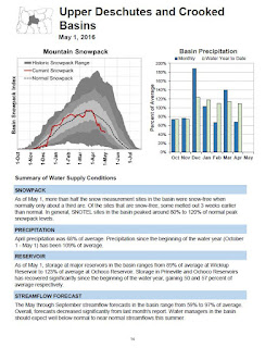
the beginning of May the NRCS report notes that over half of SNOTEL monitoring
sites in the Desches basin were snow free, compared to one-third in an average
year. Although the monitoring sites recorded peak snow levels of 80 to 120% of
normal during the winter, some sites melted out three weeks earlier usual.
Reservoir
storage as of May 1 ranged from a low 89% of average at Wickiup Reservoir to
129% at Ochoco Reservoir.
The
complex balance of remaining snowmelt to feed reservoir storage and storage at
the beginning of irrigation season has been of particular concern this year as
litigation and negotiations continue to address issues related to the Oregon
spotted frog, listed as threatened under the federal Endangered Species Act.
The
NRCS report forecast a wide range of potential streamflows going through
September.
“The
May through September streamflow forecasts in the basin range from 59% to 97%
of average. Overall, forcasts decreased significantly from last month’s report.
Water managers in the basin should expect well below normal to near normal
streamflows this summer,” the NRCS concludes.
Apart
from the NRCS report, a look at historic reservoir storage at Wickiup over
serveral years shows a continued decline in water storage in late April with water released at the dam for irrigation and remaining at the season in
late September.
As
of April 30, 2012, the hydromet water gauge at Wickiup recorded 200,223 acre
feet of stored water, essentially a full reservoir. On the same date this year,
the gauge recorded 164,333 acre feet, nearly 18% less.
Even
more dramatic are readings of 107,931 acre feet on September 30 of 2011,
compared to 17,231 acre feet on the same date of 2015.
As
such, the lower levels at the end of irrigation seasons portend the need for a
healthy snowpack and normal snowmelt patterns during Winter and Spring months
to build up storage for the following summer.
