Thursday, May 12, 2016

A broad range in Deschutes Basin water forecast - early snowmelt a concern


            Although the Deschutes basin snowpack reached levels above normal this winter the forecast for stream flows during the summer reflects considerable uncertainty.
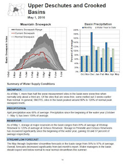
            In its May 1 report for all Oregon basins, the federal Natural Resources Conservation Service noted that an average or above normal snowpack through many state basins melted off rapidly with warm April temperatures.
            At the beginning of May the NRCS report notes that over half of SNOTEL monitoring sites in the Desches basin were snow free, compared to one-third in an average year. Although the monitoring sites recorded peak snow levels of 80 to 120% of normal during the winter, some sites melted out three weeks earlier usual.
            Reservoir storage as of May 1 ranged from a low 89% of average at Wickiup Reservoir to 129% at Ochoco Reservoir.
            The complex balance of remaining snowmelt to feed reservoir storage and storage at the beginning of irrigation season has been of particular concern this year as litigation and negotiations continue to address issues related to the Oregon spotted frog, listed as threatened under the federal Endangered Species Act.
            The NRCS report forecast a wide range of potential streamflows going through September.
            “The May through September streamflow forecasts in the basin range from 59% to 97% of average. Overall, forcasts decreased significantly from last month’s report. Water managers in the basin should expect well below normal to near normal streamflows this summer,” the NRCS concludes.
            Apart from the NRCS report, a look at historic reservoir storage at Wickiup over serveral years shows a continued decline in water storage in late April with water released at the dam for irrigation and remaining at the season in late September.
            As of April 30, 2012, the hydromet water gauge at Wickiup recorded 200,223 acre feet of stored water, essentially a full reservoir. On the same date this year, the gauge recorded 164,333 acre feet, nearly 18% less.
            Even more dramatic are readings of 107,931 acre feet on September 30 of 2011, compared to 17,231 acre feet on the same date of 2015.
            As such, the lower levels at the end of irrigation seasons portend the need for a healthy snowpack and normal snowmelt patterns during Winter and Spring months to build up storage for the following summer.


Tuesday, May 10, 2016

Bend preparing to submit its "redo" of UGB plan - Includes more density and mixed use


            After years of effort, punctuated by an order to fix an initial attempt, the City of Bend is closing in for another try at gaining approval of a state-mandated plan to accommodate and manage urban growth into the future.
            On April 21 the Urban Growth Steering Committe (USC) approved the Urban Growth Boundary (UGB) draft plan that has consumed many months of activity by city officials, county representatives, business and development interests, housing advocates and others from the community.
            The steering committee includes all Bend city councilors in addition to a Deschutes County commissioner and two members of the city planning commission.
            In the Fall of 2014 city staff laid out a timeline that divided the UGB planning into three phases that would culminate in April of 2016 with “adoption and implementation” of a plan that would include growth scenarios and extension of the city urban boundary.
            Oregon law requires that municipalities develop plans to insure that there is adequate land for growth within their boundaries in 20-year periods to comply with the 1970s legislated state planning Goal 14. Bend’s initial plan to predict growth by 2028 was submitted in 2008, but was bounced back in 2010 by the state Land Conservation and Development Commission “on remand.”
            The state agency charged with vetting the land planning process said the city had not given sufficient attention to development of “infill” undeveloped land within the current growth boundary. As a result, the city’s new plan has pared down additional acreage for inclusion in development areas to about 2,150 acres from 8,000 acres in the original 2008 proposal.
            With approval of the steering committee the UGB plan will now head to public hearings and votes by the Deschutes County Commission and the city council on the proposed boundary. The city council, acting independently of their roles on the steering committe, will also have to address how land within the boundary will be developed.
           
As presented to the steering committee and previewed for the full city council the first week in May the UGB would in theory provide for about 17,235 new residences with approximately 71%  of those within the current city boundary.

            Although the current land within the UGB can accommodate “roughly” 9,960 units, with “efficiency measures” such as revisions in density and housing mix this could increase by 23% to approximately 12,250 housing units, the findings note.
            By that benchmark ,“Bend needs to expand the UGB  to accommodate the residual need for about 4,985 housing unit to 2028.”
            In a summary of key findings the steering committee noted that most of Bend’s housing inventory for the nearly two decades from 1990 to 2008 was single family residential, and that housing prices doubled from 2000 to 2013. However, the findings note, household income only increased by 18%.
            To address the need for more affordable housing the draft UGB plan recommends targets of 55% single family detached homes; 10% for single-family attached homes; and 35% multi-family.
            In line with the housing mix objectives, the plan would increase density by lowering minimum lot size requirements in several zoning code categories.
            Among the overall measures anticipated for future development would be increased mixed-use projects combining retail/office with higher density condo and apartment type development.
            As proposed the idea would be to, “Create new walkable, mixed use and complete communities...in expansion areas by leveraging existing land use patterns inside the existing boundary...”

Bend market snapshot - 4 months into 2016


            At the end of four months into 2016 the Bend real estate market is confirming trends that have emerged in the years that have marked the region’s recovery from the bubble.
            Prices continue to rise and the availability of homes in the price segments below $300,000 continues to decline with only 10 homes on all lot sizes selling below $200,000 through April 30 this year and a decline of 11.48% of unit sales in the $200,000 to $300,000 range.
            At the same time sales in the $400,000 to $499,999 range rose more than 30%; $500,000 to $599,999 by 38% and $600,000 to $699,999 by 66%.
            The largest increase in any price category was in the $800,000 to $899,999 range, which increased by 183%.
            The median price of homes on all lot sizes rose to $359,200 from $330,000 in the same 4-month period of 2015, a rise of 8.85%. However, on lot sizes of less than an acre, the increase was even greater, at 15.04%, from $321,990 this year against $279,000 in the four months of 2015.
            Compare the 4-month period of 2016 with pre-crash January through April peak of 2007 when the Bend median price on all lot sizes reached $358,000, only to fall back to $299,000 in the same period in 2008. Median prices dipped to the bottom for four months in early 2011, when the median price fell to $193,450 before bouncing back to $206,450 in 2012 and continued a climb from the depths to the current level.
            Another trend indicative of market demand is the decline in days homes in the lower price ranges on less than an acre stayed on the market year to year. Median Cumulative days on the market (CDOM) in the $200,000 to $299,999 range dropped by 38.68% to slightly more than 70 days and by a whopping 78% from 165 days to 92 days in the $300,000 to $399,999 price range.


Increases from zero are not recorded as a percentage

Thursday, March 24, 2016

Federal judge denies motion to disrupt Deschutes irrigation for spotted frog


            A federal judge in Eugene has turned back an effort to force major changes in management of water releases into the Deschutes River that environmental groups claim are needed to protect the spotted frog.
            In a hearing March 22 US District Judge Ann Aiken said she was not convinced that the enviornmental groups had provided sufficient facts to justify issuing an injunction to alter water releases this Spring.
            Attorneys for the Center for Biological Diversity and WaterWatch of Oregon had asked the court to alter dam releases from Wickiup Reservoir in advance of the upcoming irrigation season.
            The injunction would have severely limited water available for irrigation downstream, especially for the North Unit Irrigation District that serves the region’s largest agricultural operations, and to a lesser extent Central Oregon and Tumalo Districts in the middle Deschutes Basin.
            Aiken acknowledged ongoing efforts to develop a habitat conservation plan to protect the frog, listed as threatened under the Endangered Species Act. She said that effort could proceed without court intervention.
            Aiken said she would issue her written opinion following the March 22 hearing. Although the plaintiffs could appeal the decision to the 9th Circuit Court of Appeals in San Francisco, a report Friday in the Bend Bulletin said they have approached Aiken with a preposal to mediate with the Bureau of Reclamation, which manages dams on the Deschutes, and irrigation districts involved in the court case.

 Previous post
 Thursday, February 18, 2016

Small frog makes big waves in Deschutes Basin: ESA listing spawns policy & legal wrangling