Saturday, January 31, 2015

Is this really Winter? Mild temperatures and low snowpack thus far


            No one would call Bend and Central Oregon a “dry” area in the libation sense with the region’s more than two dozen breweries, a few distilleries and a national reputation as a “beer town.”  But this year another dryness is raising concern.
            More than in many recent years the coming Spring and Summer regional snowpack high in the Cascades, and the ensuing seasonal runoff to creeks and rivers, will be in the policy spotlight.
            The concern is easy to explain. At the end of December 2014 the higher elevations snowpack in the Central Oregon Cascades was running above normal. Then came January, with the Bend area enjoying Spring-like conditions for most of the month following a frigid period of zero temperatures and snow just before the New Year.
            Balmy temperatures by mid-month, some nearly reaching 70, resulted in green shoots emerging under normally dormant perennials. Golf course parking lots filled up and usually popular cross-country ski areas on the way to Mt. Bachelor were essentially not skiiable.
            “The mountain” as locals refer to Bachelor has some of the best conditions on the West Coast, although the bar has been set lower. As of January’s close the snow base was running about half of a usual winter, after a decent seasonal start that allowed skiers to hit the slopes before Thanksgiving.
            The latest SnoTel report from the US Natural Resources Conservation Service notes that the water content of the snowpack in the Upper and Lower Deschutes and Crooked River Basins of Central Oregon is less than 50% of normal. And the snowpack itself as measured in inches was 28% as of January 29.
            Taking as an example the SnoTel reading at Three Creeks Meadow, an elevation of nearly  5,700 feet, the reading as of January 29 was 3.9 inches of snow water equivalent, or only 32% of the median for that date.
            Even less than the basin 28% of normal on the date was the reading at the instrument on McKenzie Pass, at  4,770 feet, where the the water content was only 24% of normal.
            Even more drastic is the report of snowpacks in the Klamath Basin of only 17% of normal and 18% in the Rogue-Umpqua. The Willamette Valley report was 28% of normal.
            The Klamath Basin has in most recent years been the focus of disputes between irrigators, federal agencies and tribal interests over balancing the allocation of water for irrigation and to support endangered fish populations.
            In Bend environmental groups have tried to halt the city’s expansion of the Bridge Creek water project, arguing that surface withdrawals from the Tumalo Creek watershed will adversely affect springs and potentially harm fish. In approving the project, which runs across Forest Service land, the opponents say the federal agency did not give adequate consideration to climate change.
            Central Oregon and the Cascades often catch up after lower early season snowpacks with heavier snowfalls in late Winter. But various agencies and stakeholders, including irrigators, are nervously watching weather forecasts given the unusual deficit thus far.
             There's that old axiom of the West that goes, roughly, "Whiskey (or beer for that matter) is for drinking and water for fighting over." Any tussles over the precious resource has been in the courts to date, but the issues could top the discussion agenda this Spring and Summer.


Reservoir levels as of Jan 29 2015


Three Creeks Meadow SNOTEL graph

Friday, January 23, 2015

Bend's west side focus of new planning process: UGB a factor as well


            There will be no shortage of scenarios to evaluate as Bend’s Urban Growth Boundary process unfolds concurrent with a newly-begun effort to map a plan for land use and transportation on the city’s booming west side.
            The issue of how the Central Westside Plan and UGB processes will mesh, rather than be in conflict, was raised midway during the first meeting January 20 of the westside plan's       22-member community advisory committee.
            Interest in both planning efforts is running high, with such emerging projects on the table as the proposed OSU-Cascades campus expansion and Galveston business corridor transportion redevelopment. The meeting drew  standing room only attendance at an OSU-Cascades campus classroom.
            In laying out the westside work plan, independent consultant and facilitator Kristin Hull observed, “It’s clear from the crowd here that there are a lot of people who want to track this process.”
            The state-mandated UGB and separate west side plan both have some overlapping committee members, which in theory should result in sharing information.
            In response to a question by Kirk Schueler, a prominent developer and former president of Brooks Resources, city official Nick Arnis said the UGB and CWP efforts would “inform” each other. Schueler is a member of committees working on both efforts. City councilor Doug Knight also serves on both committees.
            “I guess that’s my question-which one is going to inform the other,” Schueler asked.
            The task, city officials say, is to coordinate the west side plan with the UGB effort. A second UGB plan effort is underway after the state Department of Land Conservation and Development remanded an initial plan that it said did not adequately address several issues, including analysis of existing land for development within the city boundary.
            Work by the UGB participants will be used as a basis for developing “scenarios” that address land use and transportation on the westside, city officials said, taking into consideration available land and zoning.
            The west side study area is defined roughly on the west by Mt. Washington Drive on the north by Portland Avenue, on the northeast by 9th Street and generally by the Deschutes River south to Reed Market Road. It would also include a trianglular-shaped area east of Metolius Drive and South of Mt. Washington that extends back northeast to the Century Drive and Mt. Washington roundabout. (Refer to map below)
            `The advisory committee is expected to meet up to eight times to provide “input” to the city’s project management team assigned to develop the westside plan and by November of 2015 complete a “preferred land use and transportation scenario.”
            At the first meeting committee members began reviewing a report by independent consultant Anne George that outlined “community values” identified in interviews with 11 persons recommended by city officials. These included representatives of  business, non-profit service organizations and community groups.
            Among some key points in George’s report, those interviewed tended to support a vision for the west side that would include:


  • A transportation system that addresses cycling, walking and public transit
  • Managed growth with mixed uses
  • Improved east-west travel corridors
  • Varied housing types accessible to many income levels.
  • Requirements that public and private development include mitigation plans coordinated with the community.
  • Managed approach to on and off-street parking
  • Protection of access to natural areas for recreation and management of human impact
  • Active engagement of the community in land use and transportation.

        George’s report said some of those interviewed, “argued that the Central Westside already suffered from crowding and traffic congestion and continued growth should not be allowed.”
        But others, the report noted, “felt continued growth in Bend would contribute positively to the livability of Bend....,”and that “...growth would spur economic development, which would create a more stable and diverse economic future for the city.”
         Westside plan information is available on the City of Bend web site at www.bendoregon.gov/westsideplan. The next meeting of the committee is set for Thursday, February 26, 5:30-7:30 pm a the Rosie Bareis Community Campus, 1010 NW 14th Street.


Tuesday, January 20, 2015

2014 into 2015: more "normal" but prices creeping up with continued tight inventory


            Moving into the early days of 2015 a look back at the previous year could provide some clues to where the Central Oregon real estate market might be heading.
            In analyzing the 2014 numbers available through the MLS of Central Oregon database there’s a clear indication of a market continuing to recover from the several challenging years that followed the 2006-2007 peak -- or that overused “bubble” period.
            The encouraging news is that in most of Central Oregon prices are still rising at manageable levels, for now. Of more concern is that some price momentum--especially in Bend--is being driven by the shrinking inventory of housing availability in an “affordable” range more in line with the region’s median income levels.
            Although the economy and demographics of Bend and Central Oregon are changing, the area is still heavily reliant on tourism and other service industries where wages are generally lower than resource or agriculture, manufacturing and technology sectors.
            And a considerable segment of the residential market is pegged to retirement and vacation homes, even though those statistics are not measured in the local real estate database.
            In Bend the affordability issue has been closely tied to the discussion of density as the city grapples with completing a much-delayed Urban Growth Boundary plan to satisfy state land use requirements. Essentially the state has informed Bend that an earlier plan inadequately addressed potential residential building land already within the city boundary, among other issues. Bend Urban Growth Boundary 
            An example of the upwardly migrating prices can be found in 2014 single family homes sales on all lot sizes calculated in $100,000 increments up to $299,000. (Refer to Table 1-sales by market segment)
            In the eight key sub-markets of Central Oregon, incuding the largest of Bend and Redmond, sales of single family homes up to $199,000 dropped by 8.6% as those in the $200,000 to $299,000 range increased by 6.29%.
            However, in Bend--which accounted for more than 55% of all sales--the decline in sales up to $199,000 was even greater at 11.31%, while closings in the $200,000 to $299,000 range rose by 6.11%.
            Altogether, sales in the $200,000 to $399,000 range were more than half of sales in all the regional sub-markets, 52.85%, and in Bend individually, 61.64%.
            Among other notable points emerging from the 2014 statistics:

  • Bend and Redmond sub-markets  together comprised 75% of single family sales on all lots sizes in Central Oregon.
  • Redmond was especially strong with unit sales rising 15% to 881 and median prices by 10% to $205,000. Although a much smaller sub-market, Jefferson County, including Madras, saw sales increase by 28% and median prices by 25%.
  • Bend median prices rose above $300,000 to $303,750 for the first time since 2006, increasing 8% from 2013. However Bend unit sales fell slightly by 2% to 2,512 closings.
  • Sisters was the only sub-market to show a decline in both median prices, down 9% to $320,000,  and unit sales, off 3%, with 195 sales.
  • Although making up only 13.53% of the regional market Sunriver and Sisters had the highest home prices, at $369,000 and $320,000, with Sunriver resort and Black Butte Ranch near Sisters being major factors.
  • Sales at more than $1 million in the region increased by 25.87% but were only 1.25% of all closings. In Bend sales of more than $1 million rose by 29.41%, from 34 in 2013 to 44 in 2014, or  just 1.75% of  all Bend 2,511 closings.
  • Inventory of single family homes, as calculated by averaging 12 month sales on all lot sizes  remains extremely tight in Bend, at only 2.74 months, and Redmond, 3.20%, the latter which recorded  a drop of 37%. Inventory in the 5-6 month range is considered more “normal.”  The other sub-markets had inventory in mid-January ranging from just below five months to more than eight months in Sunriver and seven months in Sisters.
  • Another encouraging sign of market strength is the continued decline in the number of short sales and bank owned properties. In Bend the 2014 percentage from dropped from 8.70% to 6.57% year-to-year and from 14.39% to 8.70% for the region. That's a far cry from the 40% to 50% levels of the bust years.

Note regarding tables:
Table 1 is an overview of all Central Oregon single family home sales by individual sub-markets. Table 2 shows sales in price segments of the market for Bend individually and for all of the region.

A view of the national real estate market from CNBC

            
Table 1 
Market overview by sub-markets


Table 2          
Sales by price segments


Sunday, December 7, 2014

The Buzz: Wild about "Wild" filmed near Bend


            Central Oregon and other areas of the state are in for a new wave of attention thanks to the pre-holiday  release in theaters of the new film, Wild.
            Early positive reviews praise the performance of Reese Witherspoon, who stepped in with her indepedent production company and bought the rights to the book by Portland author Cheryl Strayed.
            The story is based on Strayed’s account of her 1,100 mile trek on the Pacific Crest Trail (PCT) with her life at a low point after a trail of bad decisions, divorce and the death of her mother.
"Wild" as featured on opening page of PCT web site
            Among the publicity for the movie  is a Dec. 5  New York Times feature by Bend resident Tim Neville who visited some of the Oregon locations for the filming.  He points out that all but seven of the locations were filmed in Oregon and only two of those on the PCT.
            The locations are stand-ins, so to speak, for actual sites along Strayed’s PCT adventure.
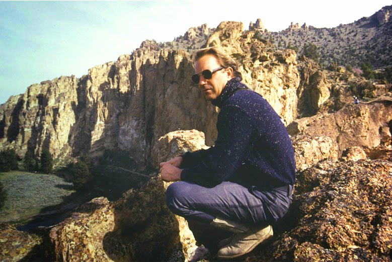
            One of the most recognizable locations is Smith Rock State Park, which was used as a backdrop still photo of Witherspoon in the movie’s promotion trailer. The crew set up at  the Ranch at the Canyons gated residential estate working ranch in Terrebonne for that filming.
"The Postman" star Kevin Costner at Smith Rock
The PCT trail overview
           The imposing scenery around Smith Rock has also been in other movies including Swordfish, The Postman and Even Cowgirls Get the Blues.
            Other Bend-area locations for Wild  include Paulina Lake Lodge, the Alfalfa Store, and Oregon Badlands Wilderness.  Scenes also were filmed around Crater Lake, Ashland, the Timberline Ski Bowl area and Portland.
            The film is expected to substantially increase hiking and visits to points along the 2,650 mile PCT that begins at the Mexican border and ends in Canada.

Saturday, December 6, 2014

BRIEFS: Population growth...brighter economy...green light for Bend water project


Deschutes again leads state in population growth rate

            More people are arriving in Central Oregon along with a better economy, and Deschutes County now leads the state in the percentage growth of  incoming residents.
That is a snapshot revealed in new population figures for Bend and Deschutes County and a report on the improving business climate.
            In its latest report, Portland State University’s population research center  estimates that the county’s population increased 4.2% in the 12 months before July 1, 2014  measured by the center.
            That translated to 3,875 new residents and a total of more than 166,000 in the county. State population grew by only 1.1% over the period according to the research center, or to about 3.4 million.
            Deschutes County was well ahead of the second highest growth county, Hood River County, which grew by 1.9%, but with only a total population of 23,730.
            Bend, as the county’s largest city, joined Salem, Beaverton, Eugene and Corvallis with growth of more than 1,000 residents in the July to July period. Portland grew by 9,390 residents.


A bright economic outlook

            On the economic side, an economic report from the University of Oregon sponsored by the Bend Bulletin, indicates a continuing increase in the Central Oregon Business Index in the third quarter of 2014 compared to the comparable quarter of 2013
            The Bulletin reported that the index, using a baseline of 100 in 1998, grew 4.3% to 124.3.
            Economist Tim Duy who directed the research attributed the growth in part to housing, but added that the increase did not signify a real estate “bubble” similar to the one that popped during the recession.
            The Bulletin reported that Duy’s research shows tourism continues to be a mainstay of the regional economy. Supporting that conclusion, lodging room taxes jumped from $1.7 million in the third quarter of 2013 to $2.2 million in 2014.
Another bright spot was employment growth of 5% year-to-year, which
brought total jobs to within approximately 3,000 of the peak 2007-2009 period.
           
A green light for Bend water project

            A decision by U. S. District Judge Ann Aiken has cleared the way for the City of Bend to proceed with construction of the much-delayed Bridge Creek water project that will include replacement of an existing pipeline along Skyliners Road.
            Aiken ruled that the Forest Service, which had issued a special use permit for construction across federal land, was not required to assess potential impacts for future withdrawals from Tumalo Creek that exceed 18.2 cfs, the current limit.
            The estimated $24 million pipline is part of a larger project that will include a new water filtration treatment system. The city has already received extensions from the federal Environmental Protection Agency which has determined the city’s current system needs to be upgraded to prevent potential contamination from cryptosporidium and other bacteria.
            Opponents including Central Oregon Land Watch have argued the environmental review did not adequately consider the effects of withdrawals on fish and future climate change. Other objections maintained that the city should rely more on less-costly groundwater withdrawals from additional wells instead of diverting surface water directly from the Bridge Creek-Tumalo Creek basin.
            Initial estimates for the entire project, including the pipeline, have approached $60 million with legal costs added to that.